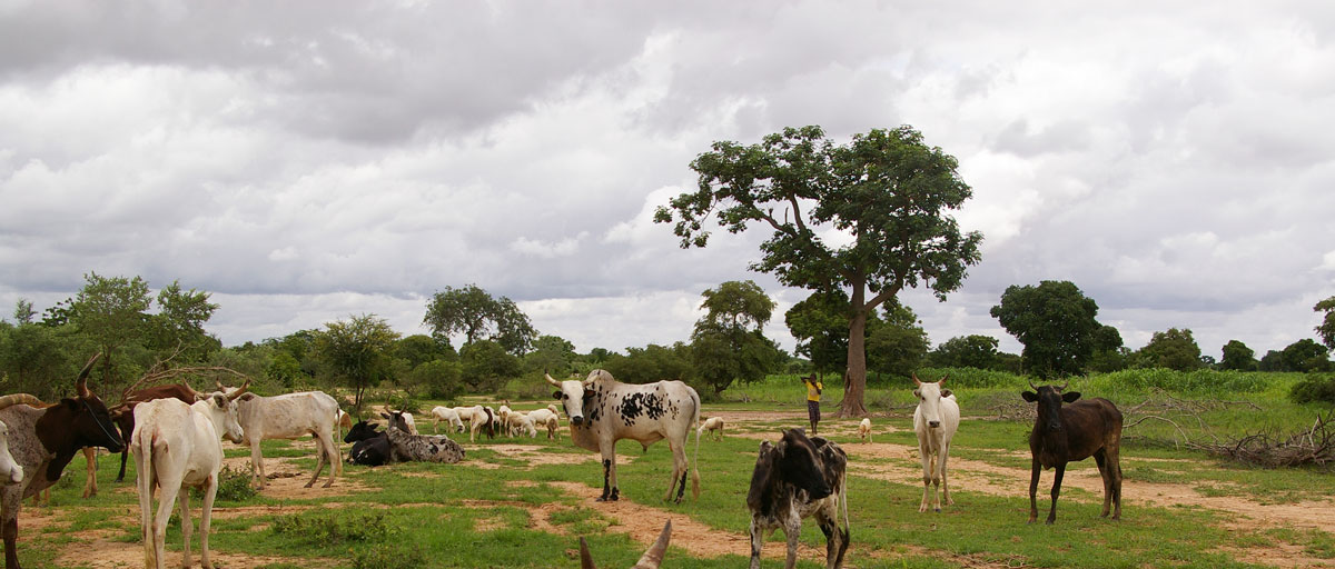
Most people in northern Burkina Faso’s Sudano-Sahelian zone have farming as their main livelihood but struggle to know how different ecosystem services are distributed in the landscapes. A new study is the first ever to map the spatial distribution of provisioning ecosystem services across the Sahelian landscape. Photo: K. Malmborg
Bildtext får vara max två rader text. Hela texten ska högerjusteras om den bara ska innehålla fotobyline! Photo: B. Christensen/Azote
Sustainable agriculture
Landscapes with benefits
New method to map livelihood benefits of ecosystem services for guiding future land use decisions in the Sahel
- First study ever to map the spatial distribution of multiple provisioning ecosystem services across the Sahelian landscape
- Both in-depth fieldwork at multiple places and remote sensing were used to produce social-ecological maps of the livelihood benefits in the landscape
- The authors see a large potential in using the resulting maps for guiding future land use decisions in the Sahel and other data scarce regions
Nine out of 10 people living in northern Burkina Faso’s Sudano-Sahelian zone live in rural areas and have farming as their main livelihood.
Many of them suffer severely from poverty and make a living by farming, keeping livestock and gathering wild plants for food, medicine, construction material and spiritual uses. And they do it in a region notorious for its low and highly variable rainfall. Living like this they are highly dependent on local ecosystem services for livelihood benefits such as nutrition, income and insurance.
In settings like these it is increasingly important, but difficult, to know how different ecosystem services are distributed in the landscapes in order to take wise decisions about land use and poverty alleviation.
This is exactly the challenge taken up by centre PhD student Katja Malmborg and colleagues in a new study published in PLOS ONE.
This study makes an important contribution to the ecosystem services literature by, identifying social-ecological patches in the landscape based on a local use perspective and explicitly attributing sets of ecosystems services and livelihood benefits to those patches
Katja Malmborg, lead author
Besides Malmborg the list of authors also includes centre colleagues Hanna Sinare, Elin Enfors-Kautsky and Line Gordon. In this study they also worked together with Issa Ouedraogo from the Consultative Group on International Agricultural Research (CGIAR).
The article in PLOS ONE builds on a previous community based ecosystem services assessment lead by Hanna Sinare and conducted in six village landscapes in Burkina Faso between 2011 and 2012. The new study, on the other hand, looks more into the potential to extrapolate these local results to a more policy-relevant regional scale.
Five livelihood benefits mapped
So far, most ecosystem services assessments at the landscape scale have used detailed secondary data (e.g. land cover maps) – something that is notoriously scarce in regions with high levels of poverty and strong local dependence on ecosystem services for livelihoods. The few existing studies based on primary data at the landscape scale have only addressed individual services.
Malmborg and her colleagues therefore chose to combine remote sensing and interviews with community members to draw their landscape scale maps of five different local livelihood benefits:
%20journal.pone.0192019.g006.PNG)
"This focus on local knowledge and use is a perspective which has been lacking in both ecosystem service assessments and policies for natural resources management in development settings in the past," Malmborg and her colleagues write.
The five local livelihood benefits identified in the maps were nutritional diversity; income; insurance/saving; material assets and energy; and crops for consumption. Together they illustrate the strong multifunctionality of the Sahelian landscapes.
The maps also highlight how important it is for local livelihoods to have a high diversity of different kinds of patches in the landscape.
“We see a large potential in using the resulting type of livelihood benefit maps for guiding future land use decisions in the Sahel,” the authors conclude.
Combining methods
The team of researchers emphasises the need to combine different methods to better understand how humans and nature interact at the landscape level. Using a combination of in-depth fieldwork at multiple places to really understand the local context and priorities, and remote sensing to be able to assess larger areas, they managed to draw maps that, with high accuracy, reveal the composition of social-ecological patches in 70–92 percent of the landscape.
"To our knowledge this is the first time that a study has shown the spatial distribution of multiple provisioning ecosystem services across the Sahelian landscape," they write.
The researchers hope that these kind of maps, grounded in local knowledge and extrapolated to regional scale, will come to use in natural resources management and landscape investments in data scarce regions, and for further research on how livelihoods might be affected by altered rainfall patterns and other landscape level changes.
Methodology
This study uses a combination of participatory methods in the field with remote sensing to produce regional livelihood benefit maps. The regional generalizability of a previous community based ecosystem services assessment was ascertained by a combination of participatory transect walks and focus group interviews in 13 villages across the two study areas. A hybrid classification method was developed to produce land cover/land use maps of social-ecological patches from Landsat satellite data and these maps were groundtruthed using the participatory transect walks. Finally, the social-ecological patch maps were converted into livelihood benefit maps using scorings from the previous community based ecosystem services assessment.
Malmborg K, Sinare H, Enfors Kautsky E, Ouedraogo I, Gordon LJ (2018) Mapping regional livelihood benefits from local ecosystem services assessments in rural Sahel. PLoS ONE 13(2): e0192019. https://doi.org/10.1371/journal.pone.0192019
Katja Malmborg's Ph.D. research focuses on ecosystem services and resilience assessments. She has extensive fieldwork experience in Burkina Faso, Ghana, Namibia and Sweden.
Hanna Sinare is a postdoctoral researcher working with synthesising SRC research on social-ecological systems, ecosystem services, and development in the West African Sahel
Elin Enfors Kautsky’s research includes efforts to identify pathways for transformative change of smallholder agro-ecosystems in various locations across sub-Saharan Africa.
Line Gordon is the deputy director at Stockholm Resilience Centre and associate professor with a focus on freshwater resources, ecosystem services and food production