Rural landscapes and agrarian spaces under soybean expansion dynamics: a case study of the Santarém region, Brazilian Amazonia
Summary
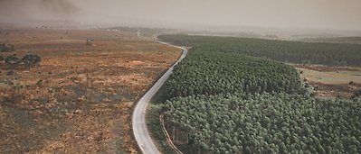
Following the boom of soybean production from 2000 to 2006 in the Santarém region of the Brazilian Amazon, the mechanized agricultural area remained stable, unlike other regions. Deforestation was controlled, but this initial expansion led to the restructuring of the agrarian space in the region. Given this scenario, we aimed to understand the mechanized agricultural expansion effects in the region by comparing the periods 1999–2007 and 2007–2015. Our hypothesis was that it impacted heterogeneous actors and land tenure categories. We combined multi-temporal land change maps derived from remote sensing to land tenure information to evaluate how land change transitions differed over time, both in public (traditional and sustainable use official settlements) and private areas. In private areas, we observed a 12% reduction in forest cover in 1999–2007 and a 2.5% reduction in 2007–2015. In sustainable use settlements, forest loss was only 3% and 2% in each period, respectively. Mechanized agriculture occupied areas of family farming (42%), secondary vegetation (20%), pasture (20%), and forest areas (18%). Family farming lost most of the area to other uses. Within settlements, the area of family farming increased by 50% at the expense of the forest area. We conclude that the rise and fall of deforestation in the Brazilian Amazon hide multiple social and territorial processes. Understanding such dynamics is critical for establishing measures toward a sustainable future.